

Blue Ridge Tunnel
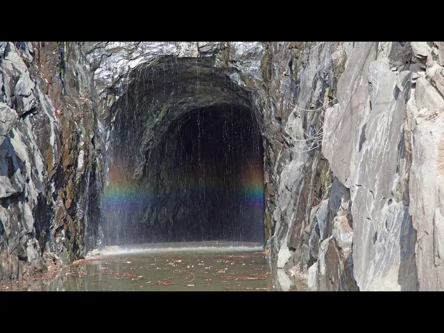
Walk the restored 1850s Blue Ridge Railroad tunnel on a 2.25-mile crushed-gravel path with dramatic stone portals linking Afton and the Rockfish Valley. The Blue Ridge Tunnel, engineered by Claudius Crozet in the 1850s beneath Rockfish Gap, now lets hikers and cyclists travel nearly a mile through the historic rail bore between Skyline Drive and the Blue Ridge Parkway.
Read More
The Blue Ridge Tunnel was designed by French-born engineer Claudius Crozet (1789–1864), one of the most influential transportation engineers of the 19th century. A graduate of the École Polytechnique in Paris, Crozet later taught engineering at the U.S. Military Academy at West Point and helped found the Virginia Military Institute.
As chief engineer, Crozet surveyed a rail route through Rockfish Gap to connect eastern and western Virginia. His plan included several tunnels, extensive embankments, and the nearly one-mile-long Blue Ridge Tunnel between Nelson and Augusta counties.
Construction proved far more difficult than expected due to extremely hard rock, particularly greenstone. Despite these challenges, Irish immigrant laborers successfully bored through the mountain, meeting with remarkable precision in December 1856.
The tunnel opened to rail traffic on April 13, 1858, becoming the longest railroad tunnel in North America at the time. Although Crozet had resigned shortly before its completion, his engineering vision was essential to the project’s success.
Learn more about the tunnel’s history at the Blue Ridge Tunnel Foundation.
About the Tunnel
The Blue Ridge Tunnel was designed by French-born engineer Claudius Crozet (1789–1864), one of the most influential transportation engineers of the 19th century. A graduate of the École Polytechnique in Paris, Crozet later taught engineering at the U.S. Military Academy at West Point and helped found the Virginia Military Institute.
As chief engineer, Crozet surveyed a rail route through Rockfish Gap to connect eastern and western Virginia. His plan included several tunnels, extensive embankments, and the nearly one-mile-long Blue Ridge Tunnel between Nelson and Augusta counties.
Construction proved far more difficult than expected due to extremely hard rock, particularly greenstone. Despite these challenges, Irish immigrant laborers successfully bored through the mountain, meeting with remarkable precision in December 1856.
The tunnel opened to rail traffic on April 13, 1858, becoming the longest railroad tunnel in North America at the time. Although Crozet had resigned shortly before its completion, his engineering vision was essential to the project’s success.
Learn more about the tunnel’s history at the Blue Ridge Tunnel Foundation.
Trail & Park Rules
The Blue Ridge Tunnel Trail is open daily from sunrise to sunset. Visitors should remain aware of other trail users, watch for uneven ground inside the tunnel, and bring flashlights or headlamps at all times.
Trailhead parking areas are small and limited. When parking areas are full, the trail is considered full. Visitors should park only in designated spaces and never along roadways. There is no overnight parking, RV parking, or camping at either trailhead.
For a less strenuous experience, including improved accessibility for wheelchair users, the east trailhead is recommended. Cyclists are also encouraged to use the east side and must always yield to pedestrians.
Help protect the natural environment by staying on designated trails and avoiding damage to plants, trees, and wildlife. Collecting plants or animals is prohibited, and visitors should pack out all trash. Feeding wildlife and releasing balloons are not allowed.
Mountain bikes are permitted only on designated roads. The use of motorized vehicles, drones, fireworks, and unmanned aircraft is prohibited. Alcohol use is not permitted, and smoking is not allowed inside the tunnel.
Overnight camping is prohibited and considered trespassing. All visitors are expected to follow Virginia law while using the trail.
Trail Conditions & What to Expect
Distance & Time
At a comfortable walking pace, a hike to the western portal and back typically takes about 1.5 hours. The trail is approximately 2.25 miles one way and 4.5 miles round trip when walking from one trailhead to the other and returning.
Trail Surface
The trail is primarily crushed gravel with some steep inclines. Inside the tunnel, the surface may be uneven due to ruts and puddles caused by constant water drip.
Lighting & Visibility
The tunnel is not lit and is very dark. A high-powered flashlight or headlamp is strongly recommended for all visitors.
Weather & Clothing
The interior of the tunnel remains cool year-round, typically between 55–65°F. Water drips continuously from the ceiling and walls, so visitors should wear appropriate clothing and sturdy, comfortable shoes.
Wet Areas & Stream Crossing
Puddles are common inside the tunnel. On the west side of the trail, a concrete stream crossing may have water flowing over it during or after rainstorms. Use caution in wet conditions.
Facilities
Portable restrooms are available at both the eastern and western parking areas but are not located along the trail. There are no water fountains on the trail, so visitors should bring drinking water.
Frequently Asked Questions
Is the trail suitable for wheelchairs?
The trail surface is crushed gravel. The east trail has minimal elevation change and is generally the most accessible option. The tunnel is unlit and remains cool year-round (approximately 55–65°F), with constant water dripping that can create puddles and ruts. Visitors should consider these conditions when planning their visit.
Trail grades and accessibility details
East Trail to Tunnel Entrance: 0.63 miles with a gentle average grade of approximately 1.5%.
Tunnel: Approximately 4,273 feet long with a gradual average grade of 1.3%.
West Trail to Tunnel Entrance: Steeper terrain with sustained grades over 5% and a maximum grade of approximately 19%. This section is more challenging.
Are dogs allowed?
Yes. Dogs are permitted on the trail and in the tunnel but must be kept on a leash at all times. Owners are responsible for cleaning up after their pets.
How long is the trail and tunnel?
The full trail from one trailhead to the other is approximately 2.25 miles. The tunnel itself is nearly one mile long.
From the east trailhead through the tunnel: approximately 1.44 miles. From the west trailhead through the tunnel: approximately 1.62 miles.
Who manages the trail?
The trail and tunnel are owned by Nelson County and maintained by the Nelson County Parks and Recreation Department.
Are restrooms or amenities available?
Portable restrooms are located at both the east and west trailheads. There are no restrooms or water fountains along the trail.
What are the visiting hours?
The trail and tunnel are open daily from sunrise to sunset.
Is the tunnel lit?
No. Visitors must bring high-powered flashlights or headlamps to safely travel through the tunnel.
Can I ride a bike on the trail?
Yes. Cyclists are encouraged to use the east trail, which has gentler grades. The west trail is steeper and best suited for experienced riders. Bicyclists must yield to pedestrians and be prepared for wet, uneven conditions inside the tunnel.


