Directions | FAQ | Rules | History
Walking at a comfortable pace, the hike to the western portal and back will take roughly 1.5 hours. The trail is crushed gravel; there are some steep inclines. One way mileage is 2.25 miles, and round trip from one trailhead to the other and back is 4.5 miles.
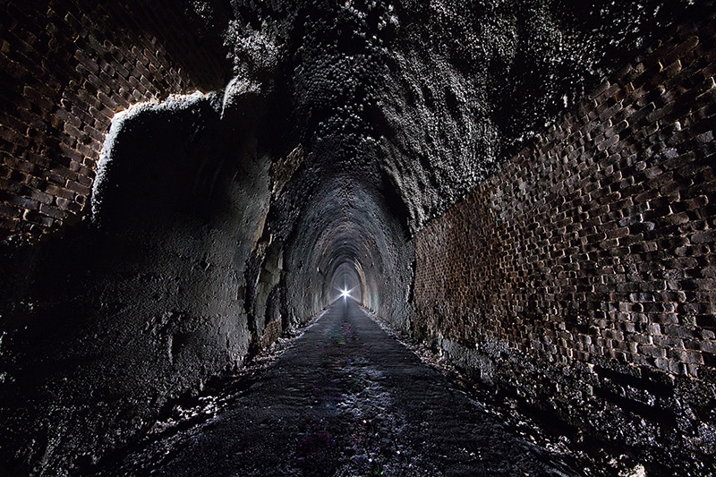
- The tunnel does not have lighting and the tunnel is dark. The use of a high-powered flashlight or headlamp is recommended.
- Wear comfortable shoes. There will be puddles of water inside the tunnel.
- Dress appropriately as the inside of the tunnel stays cool at roughly 55-65 degrees Fahrenheit depending on the time of year. Water drips from the top and the sides constantly.
- The dripping water also creates ruts and puddles on the tunnel interior trail path, be cautious when walking and/or biking.
- One section on the west trail includes a concrete mat stream crossing that may have water flowing over it during or shortly after rainstorms.
- There are portajohns at both the eastern and western parking areas but not along the trail.
- There are no water fountains along the trail. Bring water from home for your hike.
Frequently Asked Questions
The trail is crushed gravel. The east trail has little change in elevation. The tunnel does not have lighting. Headlamps and/or high powered flashlights are strongly recommended. It stays cool inside the tunnel at roughly 55-65 degrees Fahrenheit depending on the time of year. Please note that water drips from the top and sides of the tunnel interior constantly, creating ruts and puddles on the interior of the tunnel trail path and is a natural occurrence.
Here’s trail slope and grade information:
East Trail to East Tunnel Entrance
Length 3,346 ft. (0.63 miles) net change in elevation +37 feet, max. grade 5.3% for 150 feet, most of the rest of the east trail is < 1.6% ; avg. 1.5%
Length of Tunnel
4,273 feet; change in elevation +55 feet; average grade 1.3%
West Trail to West Tunnel Entrance
Length 4,279 feet; change in elevation +175 feet; grades range from -17% to +19% for lengths of 150+ feet with grades over 5% for a majority of the trail; average grade is 6.5%; max grade 19%. One section includes a concrete mat stream crossing that may have water flowing over it during or shortly after rainstorms.
Trail width is 10 ft.
Cross Slope 1-2% for the entire trail.
East Trailhead to West Trailhead: 2.25 miles.
Yes. Leashes are mandatory and you must clean up after your furry friend.
The trail is a total of 2.25 miles from one trailhead to the other. The tunnel is 4,273 feet, which is almost a mile long.
From the east trailhead through to the end of the tunnel is: 1.44 miles
From the west trailhead through to the end of the tunnel is: 1.62 miles
Nelson County owns the trails. The Parks and Recreation Department maintains the trail and tunnel. For questions, please call 434-263-7130.
There is a portable restroom at both the east and west trailheads. Picnic tables are coming soon. Please call 434-263-7130 for updates.
The tunnel is open from sunrise to sunset.
No. Visitors need to bring high-powered flashlights or headlamps.
Yes. Please note that water drips from the top and sides of the tunnel interior constantly, creating ruts and puddles on the tunnel trail path and is a natural occurrence. The east trail leading to the tunnel has little elevation change. The west trail is best for experienced mountain bikers and has steeper hills. See below:
East Trail to East Tunnel Entrance Length 3,346 feet (0.63 miles); net change in elevation +37 feet, max. grade 5.3% for 150 feet, most of the rest of the east trail is < 1.6% ; avg. 1.5%
Length of Tunnel 4,273 feet; change in elevation +55 feet; average grade 1.3%
West Trail to West Tunnel Entrance Length 4,279 feet; change in elevation +175 feet; grades range from -17% to +19% for lengths of 150+ feet with grades over 5% for a majority of the trail; average grade is 6.5%; max grade 19%. One section includes a concrete mat stream crossing that may have water flowing over it during or shortly after rainstorms. Trail width is 10 ft.
Cross Slope 1-2% for the entire trail.
East Trailhead to West Trailhead: 2.25 miles.


